Main Banner

Frequently Asked Questions - Survey & Mapping

We provide professional drone survey services, thermal drone surveys, 
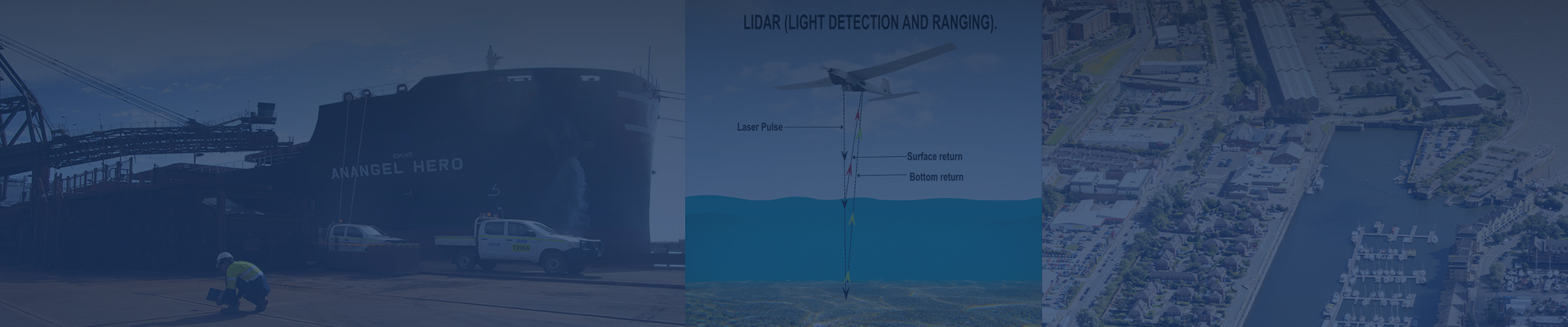
LiDAR mapping, 3D scanning, mobile mapping, utility detection, GIS mapping, traffic surveys, bathymetric surveys, remote sensing services, and structural monitoring for construction, infrastructure, mining, energy, and industrial projects.
Our drone survey services use high-resolution photogrammetry, thermal imaging sensors, multispectral cameras, and LiDAR systems to deliver accurate aerial imagery, thermal maps, 3D terrain models, and georeferenced data for topographic, engineering, construction, and asset inspection applications.
Survey accuracy depends on technology: Terrestrial Laser Scanning (TLS) provides millimeter-level precision, drone LiDAR mapping delivers sub-decimeter to centimeter accuracy, GNSS-based surveys ensure high-precision georeferencing, and thermal and remote sensing data are radiometrically calibrated for reliable anomaly detection and analysis .
We provide orthomosaic maps, thermal heat maps, 3D terrain models, DEM/DTM, contour maps, volume calculations, floodplain mapping, thermal anomaly reports, 3D site visualizations, and GIS/CAD-ready datasets for construction planning, infrastructure design, inspections, and project monitoring.osts.
Yes. Our LiDAR mapping, drone survey services, thermal drone inspections, TLS, mobile mapping, and remote sensing solutions enable accurate surveys in dense vegetation, urban environments, uneven terrain, hazardous zones, and large-scale linear projects such as highways, pipelines, power corridors, and rail networks.
We provide subsurface utility detection and mapping using Ground Penetrating Radar (GPR), electromagnetic cable locators, GNSS technology, and thermal imaging where applicable to locate water pipes, gas lines, electrical, and telecom networks with depth estimation, 3D profiling, and CAD/GIS-ready deliverables.
Our GIS mapping and remote sensing services deliver accurate, schema-compliant geospatial data derived from satellite imagery, UAV data, and field surveys. These support asset management, environmental monitoring, infrastructure planning, urban development, land-use analysis, and spatial decision-making.
Yes. Our traffic survey services include Manual Classified Counts (MCC) and Automatic Traffic Counts (ATC) for vehicle classification, traffic volumes, speed analysis, and directional flow, supporting road design, intersection planning, and traffic management studies.
Yes. Our bathymetric survey services using Multibeam Echo Sounders (MBES), UAV mapping, and coastal remote sensing deliver high-resolution land–sea models, seabed surfaces, DTMs, cross-sections, and CAD/GIS-ready outputs for ports, resorts, jetties, and coastal infrastructure projects.
We offer structural monitoring survey services including settlement measurement, deformation analysis, inclinometer monitoring, and dynamic sensor analysis. Technologies include total stations, laser scanning, thermal inspections, accelerometers, and tilt sensors for buildings, bridges, tunnels, and critical infrastructure.
Yes. Our thermal drone survey services detect heat loss, moisture intrusion, electrical faults, insulation defects, and structural anomalies. Thermal imagery is widely used for building inspections, solar farms, power lines, industrial facilities, pipelines, and preventive maintenance programs.
Yes. We supply experienced surveyors along with GNSS systems, Total Stations, precision levels, and UAV platforms equipped with LiDAR and thermal sensors for project-based or contract hire.
Survey data delivery depends on project size and scope. Drone surveys, thermal inspections, TLS, and 3D scanning are typically delivered within 3–10 business days in CAD, GIS, BIM, or client-specified formats.
Yes. All surveys comply with engineering, construction, and geospatial standards. Our workflows include QA/QC procedures, georeferencing validation, and thermal data calibration, ensuring accurate and regulatory-compliant deliverables.
Simply share your project details, site location, and deliverable requirements via our website or email. Our team will recommend the most suitable survey technology—including drone, LiDAR, thermal, or remote sensing—along with methodology, timeline, and cost estimate.
Up